Maps
Lunr's map feature uses document metadata and geospatial data to provide location-based document discovery, while allowing administrators to configure map display settings, default views, and external GIS integrations such as Esri feature services.
Overview
The Lunr map feature provides a visual, geospatial way to locate and interact with documents, enhancing traditional search with location-based context.
The map view displays documents that have been tagged with GPS coordinates, allowing users to explore document locations directly on an interactive map. Documents appear as clustered markers that expand into individual points as users zoom in, making it easy to navigate large volumes of geographically distributed data.
Users can further refine results using location search, metadata filters, or polygon selection to isolate documents within a specific area.
The feature also supports integration with external geospatial layers, such as Esri feature services and KML data, enabling organisations to overlay asset information and retrieve documents in context, such as selecting a physical asset on the map to access associated drawings. Esri feature services are configured on this page, below; KML overlays are a map viewing feature rather than a setting configured here. This makes the map feature particularly valuable for field-based workflows, where fast, intuitive access to location-specific documents improves efficiency and reduces the risk of selecting incorrect information.
General
Configure the options for displaying the map to users.
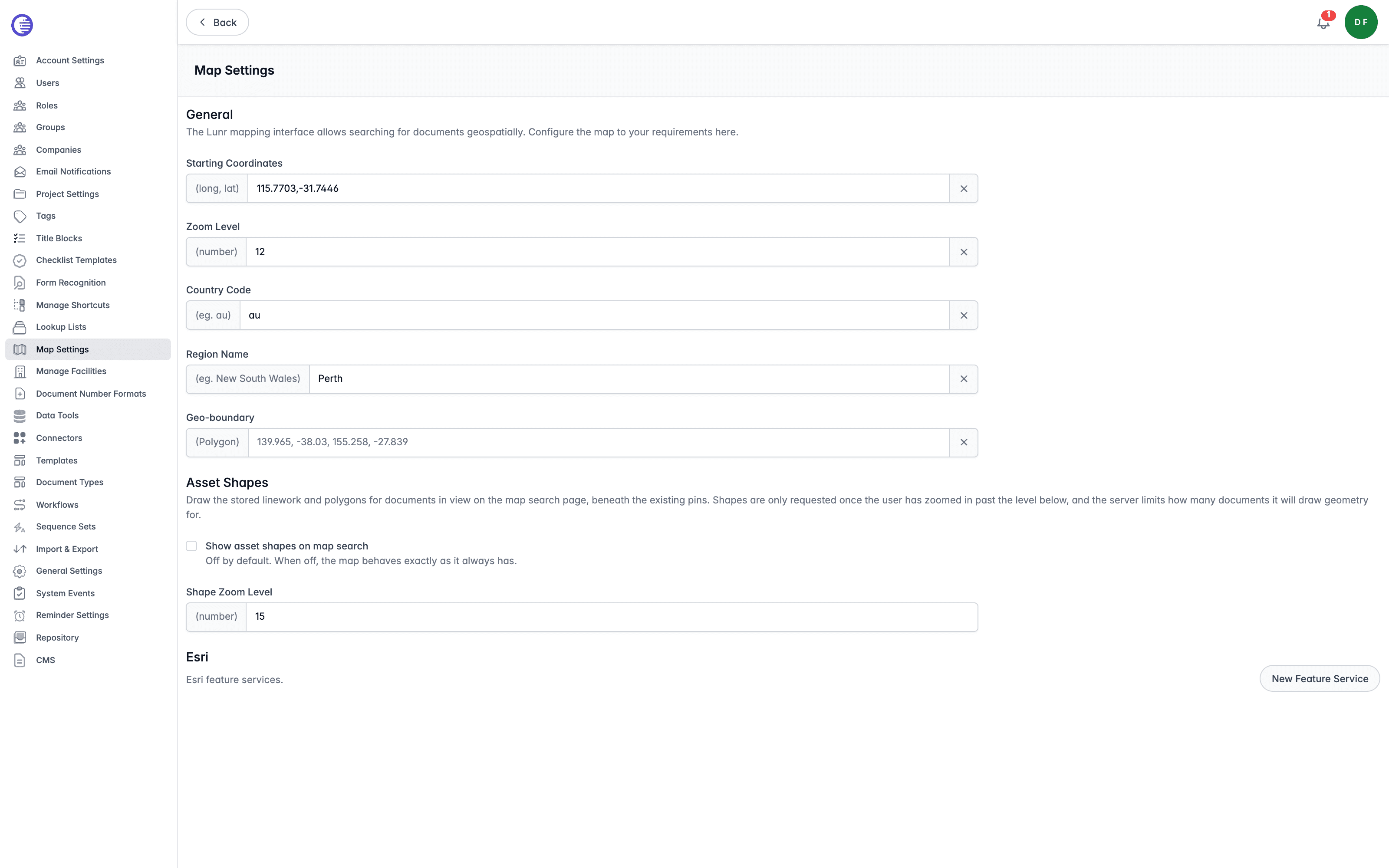
Starting Coordinates
Enter the starting coordinates in longitude, latitude format. This coordinate will be the centre of your map.
Zoom Level
Zoom Level is the default amount that the map is zoomed in from the satellite image. This is a range from 1 to 20, with 1 being the furthest away and 20 being almost close enough to count the blades of grass on the football field.
Country Code
Country Code narrows location search to a specific country, entered as its two-letter code, for example au for Australia.
Region Name
Region Name further narrows location search to a named region within that country, for example New South Wales.
Geo-boundary
Geo-boundary sets a bounding polygon that further restricts location search to within that area. Enter it as west, south, east, north coordinates, for example 139.965, -38.03, 155.258, -27.839.
Asset Shapes
Draws the stored linework and polygons for documents in view on the map search page, beneath the existing document pins.
Show Asset Shapes on Map Search
Select the Show asset shapes on map search option to draw shapes on the map. It is disabled by default; while disabled, the map behaves exactly as it always has.
Shape Zoom Level
Shape Zoom Level is the zoom level a user must reach before shapes are requested. Shapes are only requested once a user has zoomed in past this level, and the server limits how many documents it will draw geometry for, so a high value keeps requests light on a busy map.
Esri
Esri feature services can be configured to display extra layers, such as boundaries, on the Lunr map.
Only public ArcGIS Online feature services are supported. Lunr validates the URL against an allow list of ArcGIS Online endpoints, services.arcgisonline.com, services.arcgis.com, and basemaps.arcgis.com; a self-hosted or on-premises ArcGIS Server is not supported, and any other URL is rejected.
Esri feature services make anonymous requests only. There is no field anywhere for a credential, token, or API key.
Adding a Feature Service
- Select New Feature Service.
- Enter a Name and Description, then enter the feature service's URL.
- Select Create.
Lunr fetches the feature service's layers immediately when you create it. If a layer fails to load during this discovery, it is silently skipped, so a service can end up with fewer layers than it actually has, with no warning shown.
A feature service's layers can never be refreshed by editing it. To pick up new or changed layers, delete the feature service and add it again; there is no other way to make Lunr recheck ArcGIS for changes.
Feature Service Details
Select a feature service from the list to open its details. Select Edit to change its Name, Description, or URL, then Save. The Active checkbox is an administrator-set switch that adds or removes the feature service from the Lunr map; it is not a live indicator of whether ArcGIS is currently reachable. Select Remove service to delete the feature service from Lunr's map.
Layers
Each layer discovered when a feature service is registered has its own display settings, which save immediately as you change them; there is no separate Save button for the layers list.
| Setting | What it controls |
|---|---|
| Colour | The colour markers for this layer are drawn in on the map. Defaults to #00cfc4. |
| Label attribute | Which of the layer's fields is shown as a label on the map. |
| Min zoom level | The zoom level a user must reach before this layer is drawn. |
| Group name | Groups this layer with others under a common heading in the map's layer picker. |
| Is enabled | Whether the layer is drawn on the map at all. |
Form Recognition
Register the models your organisation has trained for form recognition, and map the fields those models read to the tags Lunr should fill.
Title Blocks
Synchronise data between a drawing's title block and the equivalent Lunr tags, so tags are populated automatically when a matching drawing is uploaded.